Over the past 24 hours, Laura has rapidly intensified and as I start this blog has been upgraded to category 3 status…a major hurricane, as it churns towards the LA/TX shoreline with landfall expected overnight tonight into Thursday morning. Laura may strengthen more today as well as conditions are favorable for the next 12 hours for additional strengthening.
For the KC region…we may see some outer clouds from the storm tomorrow into Friday but odds are we won’t get any rain from the storm as it moves through southern/southeastern MO Friday. For KC there will be several changes coming including a cold front moving in to start the weekend, breaking the 90s heat…and then next week a more favorable set-up for additional rains and cooler days.
______________________________________________________________
Forecast:
Today: Sunny and hot again with highs in the low>mid 90s. Dew points are still tolerable so there won’t be much of a heat index like the last several days
Tonight: Fair and mild with lows near 70°
Tomorrow: Partly cloudy in the afternoon…there is a remote chance of a few isolated showers/storms for areas from KC southwards. Highs closer to 90° or the lower 90s. A bit more humid as well
Friday: Mostly sunny and hot again with highs in the lower 90s and more humid as well.
_______________________________________________________________
Discussion:
Let’s start with Laura…a major hurricane now.


Aside from the wind and the locally heavy and flooding rains…storm surge is going to likely be a huge issue as this part of the Gulf is very vulnerable to landfalling hurricanes coming up from the south. Storm surge flooding could go 20-30+ miles inland through the low lying marshy areas of the coastline. The waters back up through the bayous and that creates bigger issues.
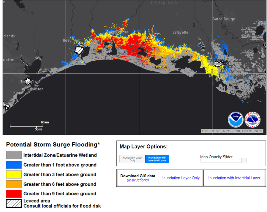
Landfall looks to be close to or perhaps just east of the TX/LA border region at this point.
Laura has been going through rapid intensification since yesterday. There are some questions about whether or not wind shear will impede the intensification as it gets closer to shore but odds are it will be formidable as it comes ashore overnight.
It may also at some point today reach category 4 status because there are some stronger winds according to recon on the northern side of the storm at flight level. We’ll see if those winds work their way closer to the surface. Even IF the storm “weakens” before landfall because of shear…it won’t affect the rate of storm surge into the coastal areas as that part won’t have time to “relax” before coming ashore.
It appears that this storm will be just towards the east of Hurricane Rita back in 2005. Rita did $8 billion in damage in Louisiana alone. It should be noted that while Laura will be dropping from hurricane status Thursday the strong winds will be an issue (not to the same degree but still strong) all the way into the TN Valley.
Again it appears most of the effects, aside from maybe some cirrus clouds will remain towards the south of the KC region.
Our next weather maker…and the one that will break the heat is going to be a weak front moving through later Friday into Saturday morning. This will give us at least a chance of some storms/rain but with the front’s timing and the waning instability it may be tough to get a lot of coverage. We should “cool” down into the mid 80s though for the weekend with some cooler weather on Sunday morning.
A stronger front is likely on Monday…and ahead of that front there may be stronger storms sometime later Sunday night into Monday morning…as a matter of fact there might be some severe storms somewhere around the area. This offers the best chance of rain in the region in the last couple of weeks. The front itself may not pass through till later Monday and then we’ll see if it stalls to the south of here. IF it does…that could mean more rain on Tuesday as well because the front may be retreating northwards again.
So as we start September we start with multiple rain chances…which should break the dry stretch of weather out there. We’ll see how we end up for the month with rain in August. There are chances…and IF the rain comes in a bit quicker on Sunday…before 12AM…we could certainly add to the totals before the end of the month.
The issue of getting to 95° for a high though may remain elusive. Assuming we don’t get there today…we probably won’t get there tomorrow or Friday…and then we start seeing better cold fronts coming this way into September. Never say never but the odds are dropping after today.
OK that’s it for today…have a great Wednesday and stay cool. The feature photo today is from Sandra Cox down at the farm…pretty scene.

Joe