I’ll be taking a couple of days off tomorrow and Friday…so no blogs again till Monday and perhaps by then there may have been some showers in the area…or at least we can see when there might be a better chance of rain showing up. It’s getting rather dry, and quickly, out there. Lower dew points…a high August sun angle and a bit of wind really will dry out the top soil quickly.
There may be at least some scattered showers on Sunday…maybe…perhaps…hopefully…don’t count on a lot though.
_______________________________________________________________________
Forecast:
Today: Sunny and mild with highs 80-85°
Tonight: Fair and pleasant with lows near 60°
Tomorrow: Sunny and mild with highs in the lower>mid 80s
Friday: A pinch warmer with highs in the mid 80s
________________________________________________________________________
Discussion:
It’s great out there again today…good for all of us but not so great when you’re trying to write a weather blog…so perhaps my days off are well-timed.
So as I mentioned…we’re drying out quickly. We’re running below average for August…including today…it will be close to 1.7″ worth below average. So rain would be welcome. We’re also now about 4° below average for the month of August as well.
Temperatures have been lovely and the humidity levels have been great lately. Only slowly will we see both increase and frankly it may not be till next week sometime that it gets overly muggy again. It will feel more like August as temperatures gradually creep upwards well into the 80s into the early part of next week.
So far this year we’ve had 30 days of 90°+ weather…only once though this month. The record for fewest 90°+ days is 4 set back in 1913 and 1947. We have some work to do next week to get there. We should get to at least 4…but it might be a struggle. I do expect warmer weather overall next week.
Now as far as the rain goes…that is another issue. I talked last night about how we can’t let our guard down with disturbances coming from the north or northwest. There were a lot of clouds yesterday in the afternoon for awhile from one of these and there have been some showers on the KS side west of the region lately and there are a few again this morning. These little buggers can create “surprise” rains if they track in the right direction.
Right now we should be pretty good for a few more days…worth watching but with the big heat wave generator breaking all sorts of heat records in the western US these days…anchored where it is…the track of most of these waves will be west of the region.
The issue for KC is when will this heat wave generator expand somewhat into the Plains and will a wave come down in the flow as it expands eastwards. The models haven’t had a lot of consistency with these ideas but we may be slightly more vulnerable to something over the weekend…perhaps on Sunday.
So at least there may be some scattered showers over the weekend…again perhaps on Sunday, mainly in the AM hours…but really it’s not worth worrying about at this point…tough to see how much we can truly get from this anyway. As a matter of fact there is a lot of data this morning suggesting the rain amounts may only be in the 1/10-1″ range for the rest of the month.
Finally on this pretty summer morning…the Old farmers Almanac came out with their winter forecast yesterday…
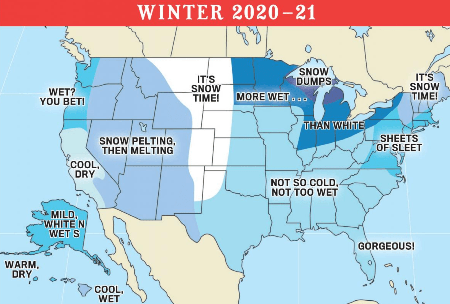
So there’s that…seems more vague than usual. Although they’re saying that most of the US will be milder than average.
Our feature photo comes from Donna Barron. Pretty colors!

Joe