Good Monday to you…it was a hot weekend around thee parts and it will be an overall hot week as well with moderate to high dew points developing as the week moves along. Temperatures will also be toasty and above average for most of the week continuing a trend that started for highs at least over the past weekend.
The other issue to watch is the tropics and despite the crazy and misleading headlines and all the fancy terms that were thrown around last week that won’t come into play…the main system to watch is Laura. Yes there is Marco along the Gulf Coast but it’s really not a major system at all aside from some locally heavy rains in NW FL and AL today. It’s weakening.
Laura though is the main one to watch and while there have been some crazy click bait headlines out there and frenzied national media hype…Laura is the main issue later this week for the Gulf area especially LA and TX it appears.
____________________________________________________________________
Forecast:
Today: Sunny and hot with highs in the low>mid 90s
Tonight: Fair and mild with lows in the upper 60s
Tomorrow: Ditto
Wednesday: Ditto
_____________________________________________________________________
Discussion:
It’s getting pretty dry out there…you can really see it in the grass and this week won’t be overly helpful regarding the dry conditions. At least for the next 4-5 days. There may be some rain chances Friday or Saturday developing. Combined with the hot air and the reasonable dew points and that is a great combination for dry top soils.
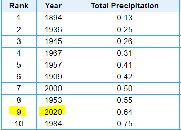
We’ve only had .64″ of rain this month…over 2″ below average. So far, through today’s date, this is the 12th driest August in KC weather history…again that is through the 24th.

If you wanted to take it through the rest of the month…assuming it doesn’t rain through Sunday…then this would be the 9th driest August.
I do think at least there will be some rain chances before Sunday though…we’ll see how well things come togetther.
This more or less typical summer heat (although the dew points are below average) will continue into Wednesday and probably Thursday (at least). There is a question about whether or not some clouds may help cool things off a bit on Thursday and Friday.
The tropics are the main issue out there, although there are a lot of wildfires going strong out west and we’ve had a lot of smoke in our skies lately from them. Marco is really not a major thing…it was a hurricane but has encountered so much shear and to some extend dry air that it’s a hot mess right now.

The center of the storm is exposed towards the SW of the main area of convection and rain…

Flooding will be the main issue today in NW FL and perhaps parts of SE LA.

Again to stress NOT a major storm despite some of the click bait headlines out there on some national sites.
Now Laura…this has more potential.

Laura is south of Cuba…or at least near the coastline. As I type this it’s a strong tropical storm. It should become a hurricane again tomorrow as it comes into the Gulf of Mexico and gets more out into the open waters and farther from land.
Once in the Gulf of Mexico it will connect with some very warm sea surface temperatures and likely a lot less shear in the atmosphere compared to what Marco is dealing with today. Water temperatures there are between 85-90°…that is some high octane gas for a tropical system.

Here is a look at Laura…it’s towards the lower right on the images below.

Most model data take the storm towards the WNW…then NW into either TX or LA heading into early Thursday. As the shear relaxes and as the storm goes over the warm waters in it’s path…there should be a strengthening trend tomorrow…and there are concerns that there could be some rapid strengthening tomorrow into Wednesday increasing the threats even more into the northern half of the TX coast as well as perhaps western LA.
The next issue will be will Laura re-encounter any shear as it approaches the coast-line later Wednesday…there is some data that suggests that could again occur…that aspect remains to be seen. The concern though is IF there isn’t shear to weaken the system…then this could be an intensifying hurricane as it comes closer to shore increasing the storm surge and the wind damage potential.

Right now Laura is expected to be a high end category 2 or maybe 3 coming into the Gulf Region…
Can we get any moisture from this? Possible but the better chances appear to be towards the south of the Metro…and perhaps more towards the I-44 corridor and the Lakes region. There may be more moisture overall in the atmosphere on Thursday to support perhaps some scattered storms developing towards the south of I-70…down towards 54 highway…should something develop down there it would have a tendency to migrate towards the north…so at least there may be some storms around somewhere…how much coverage though is a bit of an issue and right now at least it doesn’t look so great.
A cold front though will be a weather change that does look promising and that should come into the region sometime later Friday or Saturday and that should give us more coverage of rain…so again odds are we should get some rain before the end of the month.
That’s it for today…I have golf in the morning tomorrow so odds are no blog tomorrow, although depending on how Laura is doing I may try and get something together in the evening tomorrow between newscasts.
The feature photo today is from mohiker via instagram…pretty shot from Lees Summit a couple of weeks ago.
Joe