CHANCE OF ISAAC AFFECTING OUR WEATHER WITH A TRACE OR MORE OF RAIN: 85%
CHANCE OF ISAAC AFFECTING OUR AREA WITH OVER .25″ OF RAIN: 60%
CHANCE OF ISAAC AFFECTING KC WITH WIDESPREAD 1″+ OF RAIN: 30%
ALL CHANCES ARE HIGHER OUT TOWARDS THE LAKE OF THE OZARKS THROUGH CENTRAL MO
Some rather dramatic changes are in the weather cards today as the very areas in the worst drought conditions are going to see some beneficial rainfall over the next 2-3 days connected to the remnants of Hurricane Isaac, which is now spinning itself down across NC Louisiana. More on that in a second, but first let’s talk about the drought report that came out today. Really no need to dwell much on it because aside from it being drier than it was last week, but I will post the map the the NWS in pleasant Hill created just to again outline the extent of the “Exceptional” drought.

The stats to bear this out are staggering. I’ve shown them repeatedly on my weathercasts for several months now but suffice it to say when your 15+” below average since 4/1 it is stark. While Chillicothe and Sedalia are closer to 10″ below average in that same time frame, it’s still devastating.
So what can Isaac do for us. Well again remember that we average 1″ of rainfall/week during this time of the year. So let’s say that Isaac gives us 1″ of rain…well that is an “average” week of rainfall which would be great, but like I mentioned last week leading up to the fizzled rain in the metro…just a proverbial drop in the bucket compared to what we need.
The best rains again should be off towards the east and SE of the KC area. From SE KS through Butler/Nevada to Clinton To Sedalia up towards Marshall and towards Columbia and north and east to St Louis, rainfall amounts may be in the 2-5″ range.

What should be readily apparent from the radar tomorrow and Saturday is the rotating bands of rainfall around what’s left of the center of the storm. So depending on where the center goes, the rain may actually move in to your area from the east or southeast which is a little different that what typically happens.
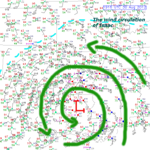
Temperatures tomorrow are tricky, a slower cloud shield in the AM allows us to warm faster, a quicker cloud shield will blunt that warming fast. So while today we’re in that 95-100° again, tomorrow shouldn’t be nearly as hot. One thing to remember is that the atmosphere, which is really dry now will get real moist fast tomorrow AM. So the dewpoints will be jumping into the 60s then perhaps 70s by tomorrow night as the rain increases in the region. Here is the latest surface map showing the storm and the wind field. I outlined the wind circulation with dashed cyan lines to show the outer edge of Isaac’s circulation.
The storm’s history from a flooding standpoint and a rainfall standpoint is impressive. There are some reports now of over 20″ of rainfall with upwards of 18″+ in the Pascagoula, MS area since midnight. Biloxi has had 17″ of rain form the former hurricane. There has also be a few tornados that while short-lived have done some damage. 9 reports yesterday and 5 today (so far)
At this point I have little faith in the modeled rainfall forecasts. There is no way they can handle the individual bands of rain rotating around the center of the storm. Again this will be a nowcasting situation tomorrow as the storm moves towards us.
Here is a look at the storm approaching the Ozarks.

Finally we’ll be tracking the rainfall across AR tonight/Thursday and an indicator about our potential rainfall.

Finally, Isaac has some company…2 other storms are out there as well. At this point none should threaten the USA…but it’s interesting that now we’re up to Leslie and that makes this hurricane season the 2nd fastest to the letter “L” in modern history. 1995 beat it by one day.

Let’s root on Isaac as it gets closer tomorrow and hope it doesn’t disappoint us like most (or all) of the rain chances have done since this thing started in early April.
Joe


