If one politician says something to the effect of “we didn’t know it was coming” or “it was worse than we thought” or “the forecasts were wrong”…they’re lying. This storm, whether it was called a hurricane, post tropical storm, “Frankenstorm” or Superstorm, whatever people were calling this thing, it delivered everything and then some to the NE part of the country.
The mayor of NYC made a mistake on Saturday when he said this referring to why he was not ordering evacuations.
“We’re making that decision based on the nature of this storm. Although we’re expecting a large surge of water, it is not expected to be a tropical storm or a hurricane-type surge,” he said. “With this storm we’ll likely see a slow pileup of water, rather than a sudden surge, which is what you would expect from a hurricane and which we saw with Irene 14 months ago.”
I’m not sure WHO he was listening to, or if he was playing meteorologist or whatever. It was clear that he wasn’t listening to his local NWS office who handled the forecasts very well while using extremely strong language in stating the risks.
In reality the Mayor did decide to evacuate “Zone A” on Sunday and it was a good call then. Many left, but some stayed and I really don’t know if more would’ve left with an earlier evacuation notice so perhaps he was just being as cautious as he could be to not needlessly get people to leave their homes. To be fair, during that same press conference he did talk about all the eventualities saying “Lower Manhattan is the most vulnerable place to a storm surge,” Mr. Bloomberg said. The storm surge, expected to be most dangerous late Monday, could be a “record,” quote according to the Wall Street Journal.
Well all that has come true. There are millions without power in the NE. The blizzard that I was expecting has materialized as well with upwards of 3 feet of snow in the higher elevations of WV and now power is out in Elkins, WV too. There were early predictions of 10 million customers losing power from this storm, and I think we’re closing in on that number today.
The coastal areas though took the brunt of the storm. Low lying areas are a mess from CT through NJ. Atlantic City was devastated. The NYC subway system is flooded in many sections. I didn’t know that in a normal day the subway system pumps out 13 million gallons of water a day. The preemptive shutdown of power hopefully helped out. Remember over the weekend how I talked about on the air with special graphics about my biggest concern out of this storm, the surge into NYC from Long Island Sound and the Atlantic. It happened unfortunately.
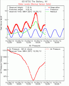
How high did the water get on the southern part of NYC. Take a look at this graph showing the tidal changes at Battery Park. The water height was several feet above the previous record as the worst of the rise of the water timed out to the high tide. That plus above average tides because of the full moon created some of the issues that have developed for the NYC area.
The Hurricane Center, I feel, despite their solid forecasts in the several days leading up to the landfall of Sandy also made a mistake, which while they were technically correct (that’s debatable in the meteorological community) perhaps was too “inside baseball” in it’s decision making process. Did you know that there WAS NOT a Hurricane Warning in effect for that part of the country? The NHC felt that since the storm was going to transition from a hurricane to what’s called a “post-tropical storm” before it made landfall that Hurricane warnings wouldn’t be a valid product. Instead that relied on the local NWS offices to issue High Wind Warnings for the region, amongst other products. To be fair, in the days leading up to this they talked about about their decision making process about this but I still think there should have been Hurricane Warnings for the coastal areas, if nothing else. According to the NHC Sandy lost it’s hurricane characteristics within about 30 miles of the coastline before landfall. again technically correct (debatable), but for the vast population of the affected area, the knowledge of what a post tropical cyclone is compared to what a hurricane is enormous and for the sake of clarity shouldn’t have been put on the line like that. I don’t think anybody would’ve done anything all that much different in their reaction/planning but it needlessly added confusion to the process and I’m sure the NHC will be hearing about it for the foreseeable future. The storm’s life was a unique thing, it’s path to landfall was bizarre and perhaps one of a kind.
With all that said, I think the folks back east had the knowledge available to them to determine what to do and how to do it. This storm did what many in the meteorological community thought it would do, there were wind gusts of 70-90 MPH+ in the NYC area, there was flooding rainfall, there was devastating coastal surge flooding amongst many other facets of the storm. I believe the media did their job as well with forecasting it for their respective viewers. Some may have thought the forecasts were wrong or it was “no big deal” but that will happen with any forecast that has such impending things in it.
Sandy now is on SW PA and will slowly spin itself down over the next few days. It’s stuck in a sense because the same upper air blocking pattern that allowed it to back up into NJ won’t allow it to move to the NE in fast fashion.

Interesting that the clouds from sandy have made it to the MS River in the St Louis area.

Tomorrow’s blog will be more of a KC blog as I’ll be watching a system for the weekend that may give some folks a little rain but I’m not confident in that. The influence of Sandy has sent dry air all the way down towards the Gulf region. That dry air is going to be tough to overcome. So whatever moves this way will have to bring moisture with it, and that usually means little if any rainfall for us here. Something to talk about tomorrow though.
Have a great day!
Joe


