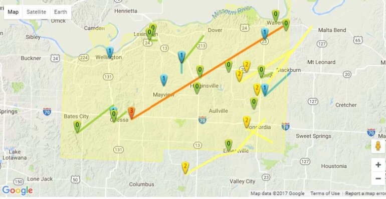
It was a busy night for storms through the region. Sadly there were numerous areas of destruction. Thankfully, to my knowledge there were no fatalities. I showed last night the path of some of the strongest circulations…and you can pretty much draw a straight line from southern JOCO to Oak Grove, MO with a storm that at times produced high winds and some touchdowns.
There’s a lot to cover in the blog and the weekend forecast is also starting to be problematic…especially Saturday.
Forecast:
Today: Sunny and windy again with temperatures around 60° and gusty west winds developing with 20-40 MPH possible.
Tonight: Clear skies and chilly with lows near 30°
Wednesday: Nice but windy with SW winds 20-35 MPH. Highs 65-70°
Thursday: Nice again and LESS windy. Highs near 70°
Discussion:
My goodness what a night. The main contributor to the tornadoes forming…and there were several in the region, was the wind shear that existed in the lower levels of the atmosphere. As I mentioned in yesterday’s blog, there are a couple of ways to get wind shear. 1) is the change in the wind direction as you go up through the atmosphere. For the classic big tornadoes that can occur…the ones that stay on the ground for a long time…typically we look for a SE wind or S wind at the surface…and SW>W>NW winds the farther up you go. This wasn’t the case last night. Another type of shear is speed shear. That occurs when the wind speeds increase as you go up in the atmosphere. That WAS the case last night and was detailed in the blog. While the tornadoes in these scenarios don’t last as long (usually) and are typically not as strong, they can, on occasion, be strong enough, and that happened last night.
I used this image in the blog to highlight how speed shear works…even though we were getting winds 20-40 MPH at the surface, the winds above us were closer to 55-65 MPH and that allowed these areas of horizontal rotations to develop.

Now the trick is getting that horizontal “rolling” to stretch into the vertical. That requires the lift of convection and the squall line that moved into the region did just that.

At night, with the right conditions (like last night) we are vulnerable to these things. I had that feeling as I wrote about in yesterday’s blog that this would be the case and that’s what happened. You’ll notice that when the tracks/paths of the storms come out…they shouldn’t be too long. The hope is that these short lived tornadoes hit in the middle of nowhere and are small in size doing little to no damage. Unfortunately a few areas weren’t so lucky.
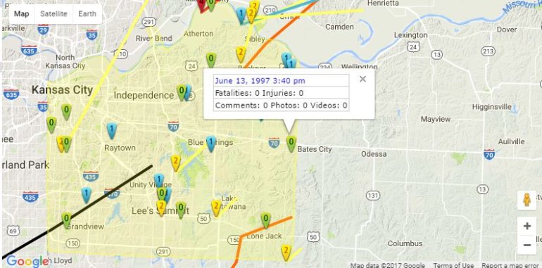
I tracked one of these storms/rotations through southern JOCO into JACO and eventually into the Oak Grove area.
Trace the path of the circulation through the southern + eastern suburbs of #KC Damage along path #OakGrove pic.twitter.com/LIKnVLGbrM
— Fox 4 Weather KC (@fox4wx) March 7, 2017
Close up of the #OakGrove circulation #mowx pic.twitter.com/Af4DHlgA88
— Fox 4 Weather KC (@fox4wx) March 7, 2017
A look at the velocity couplet moving towards and through the #OakGrove area #mowx pic.twitter.com/z9z7OIL9jT
— Fox 4 Weather KC (@fox4wx) March 7, 2017
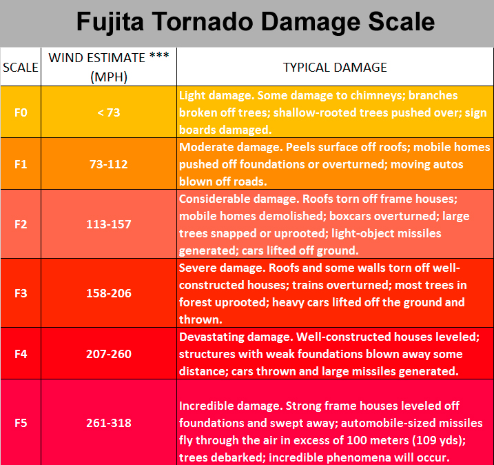
Damage reports indicate a path of roughly 7 miles. I noticed that there was a flipped car in one of the live reports last night…that would indicate to me at least EF2 type damage (113-157 MPH) in the Oak Grove area. The NWS will be assessing more of this today. Over 480 homes reported damage there…
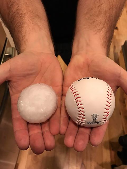
Between the damage there and in other areas it’s pretty obvious that this will be a multi million dollar event here…and that doesn’t even take into account all the hail damage in the region for hailstones that got to baseball sized. It’s not too crazy to think this may be the most damage in the region (between hail/wind/tornado) since the 2003 tornadoes in the KC area.
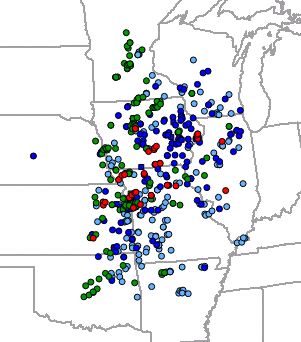
I grabbed a couple of images from the storm reports overnight. The red dots are tornado reports…green dots hail larger that 1″…blue dots winds over 58 MPHand the cyan dots wind damage reports
The bigger picture…
I did a quick analysis of the recent tornado history in E JACO, MO and Lafayette Co, MO and since Oak Grove straddles the state line…I pulled both counties…the data is through 2015.
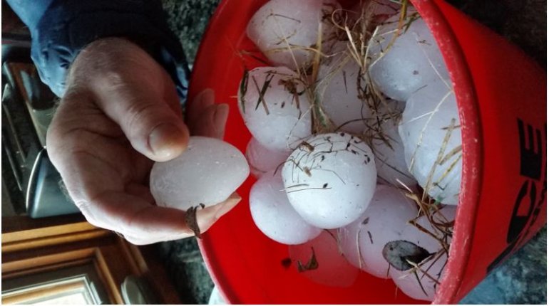
The bigger hail was an issue as well…some stones are still around…even this morning. This picture was taken in DeSoto this morning 12 hours AFTER the storm moved through.
Other likely touchdowns occurred towards the Smithville Lake area and around Trimble, MO. There was another touchdown way up in Harrison County as well…and potentially around the Carrollton area
There were some baseball sized stones out there.
Onto the Saturday situation…consider this a shot across the bow…there is going to be colder air coming into the region beginning on Friday. Temperatures will be dropping into Saturday and there is a system tracking towards the SE into that colder air. It’s far too early to get too specific on this…but the GFS model, for example…is very cold and snowy…the EURO model shows something as well (perhaps ice/sleet/snow). It’s something too watch because I’m concerned about the impacts on the Snake Saturday parade.
More on this as the week comes along.
Our feature photo comes from Jeff Abernathy out towards Lenexa (around canyon Creek)
Joe


