
It’s a snowy day in the KC area…there are some great pictures coming into my FB page (Joe Lauria Fox 4 Meteorologist) and on twitter (@fox4wx). Our winter storm continues but the heaviest of the snows NW of KC is winding down. Areas SE of KC are going to pick up more accumulating snow…and some areas have already had 10″! For picture taking this is one of the best snows in recent memory. The number of snowmen and kids having fun today should be through the roof! Be careful shoveling since this snow is a heavy and wet one…it weighs a ton…or maybe 2 tons.
- Forecast:
Today: Some more snow out there…still a few moderate to heavy patches this morning as well. An additional 1-2″ or so is possible in parts of the area…maybe a bit more farther east of KC. Temperatures around 32°
Tonight: Cloudy with steady-ish temperatures with readings in the upper 20s
Tomorrow: Cloudy with highs near 30°
Monday: Clearing (I hope) with highs in the 30s
- Discussion:
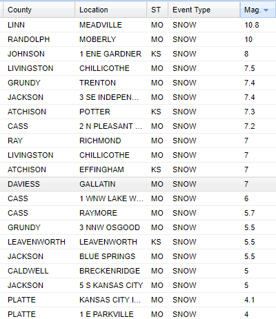
I’m very curious to see how the snow maps from this storm look in the end in terms of actual reality. Widespread 4-8″ of snow has fallen in the region. Some areas have had more snow…over 10″ off towards the east of KC…Richmond to the Meadville area got clocked pretty good. So far at KCI (@6AM) the snow amount was around 4″ or so…
As far as other snow reports go…here is what I have through 8AM or so…we’ll get more to you in the afternoon blog.
Meanwhile on the KS side…
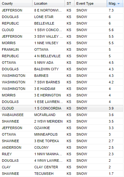
Amounts really trailed off towards the west of KC.
Karli and Michelle had 4-5″ or so…I had close to 5.5″ and it was still snowing when I left around 3:30 so I’m guessing I had more.
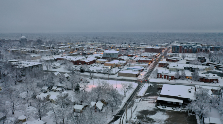
Here is a shot from OPKS via our FOX 4 drone…
It was a weird one…lots of melting for awhile, especially on the northside of KC…then once a coating got established it really started to accumulate. On the south side the accumulations happened faster and quicker.
One negative from this are the power outages…some 30,000+ so far this morning….the weight of the snow on the tree limbs aren’t a good mix.
There is more out there…here is radar.

By the way…areas farther east…towards St Louis are terrible. The snow hit hard and fast before rush hour last night…and that meant folks left work early…clogging the roads…then they couldn’t plow because of the traffic…then there were accidents and jack-knifed trailers all over the place..and that lead to folks stranded on some of the interstates…all night long…and it remains bad.
8:30 AM: I44 is blocked by incidents near STL. EB travelers on I44 coming from OK should seek a southern rt at Exit 82 (US 65). There are still 6 to 8 hour delays near STL. For travelers already near STL a detour at Exit 251 near Pacific is advised. https://t.co/opw1rHuWdm pic.twitter.com/XIQoqqrk6k
— MoDOT (@MoDOT) January 12, 2019
So it’s actually worse out there than here today.
Here is a quick look at snow and sleet accumulation for this winter storm through 6 AM. The map is an estimate based on reports that we have received #mowx #ilwx #stlwx pic.twitter.com/Sm8hylYcGA
— NWS St. Louis (@NWSStLouis) January 12, 2019
Here a look at how much more snow we'll see out of this storm #mowx #ilwx #stlwx pic.twitter.com/dHrXYjvnno
— NWS St. Louis (@NWSStLouis) January 12, 2019
It’s worth mentioning that another storm…this time with an arctic air blast may hit the region later next week. That will be the next significant weather maker for KC.
Until then we’re going to have to contend with melting snow and how that moisture in the lower part of the atmosphere messes up our potential sunshine…and may or may not contribute to overnight fog issues as well. IF we didn’t have the snow…and it’s extensive…we’re be in the 50s on Tuesday. Alas not going to be the case this week.
That’s it for now…pictures are coming fast and furious…
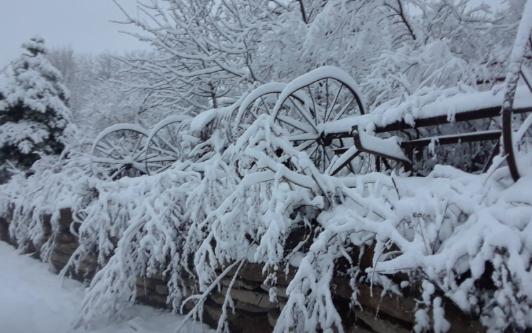
The feature photo comes from Alisha Ann…
Joe


