
Good afternoon…it’s warm and breezy out there today. Actually had to turn on the A/C in the car this afternoon heading back from the K after doing a photo shot for School Day At The K…coming up on Thursday 5/4. By the way…any ticket purchased…either via group sales or just wanting to go to the game gets you complimentary admission to the largest live weather show in the ENTIRE world…think about that for a minute…
Hopefully the weather then will be as good as today. We’re into the 80s this afternoon and while we’ll hold onto the warmth for another day on Friday it will come crashing down on us later Friday night into Saturday morning. So much so that some snowflakes are still possible before the weekend is done.
Forecast:
Tonight: Fair skies followed by increasing low clouds near daybreak. Windy and mild with lows well in the 60s
Friday: Very windy in the morning…gusts may exceed 40 MPH…then mostly cloudy with perhaps a few misty patches before lunch then after 3-5PM or so the risk of storms will move in from the KS side into the MO side during the evening. There is a risk of some severe weather (main threat being gusty winds of 60 MPH+ and some hail 1″+). Right now I’m not expecting a lot of coverage to this but it’s worth monitoring especially in NW MO and east of the KC area in the evening.
Saturday: Blustery and colder with falling temperatures into the 30s by the late afternoon (if not earlier). Cloudy skies and there may be a few spits of drizzle or even a random snowflake/pellet
Sunday: Lots of clouds with perhaps a few snow showers in the morning…highs in the 35-40° range
Discussion:
The situation for tomorrow continues to evolve. The update from the Storm Prediction Center has increased the likelihood of severe storms in the later afternoon and evening, especially on the MO side.

As we focus more into eastern KS and MO…this is what it looks like.

Something about this still looks “off” to me. This is somewhat common during early season set-ups. I’m not sure what my main concern is at this point…but I wonder about the “quality” of moisture return…and how the gusty AM winds may “mix out” the best moisture in the lower part of the atmosphere. There will be a surface low in NW MO near the SE NE/SW IA region…and that deserves some respect for the potential of some more rotating storms towards the east of the low…along the MO/IA border region especially…again what happens will happen very quickly. We may remain capped through 3PM…then as the storms try and form…they may not get their act together fast enough to impact KC that badly. Obviously this is subject to change but whatever happens with the storms they will be moving so fast that their time affecting you’re location will probably be less than 30 minutes…perhaps less than that.
I wouldn’t be surprised if most of KC doesn’t even see much of anything really in terms of rain BUT…but you can’t argue too much with the set-up in general so we just have to be vigilant. Should the storms fire up and combine with the strong wind shear (covered in yesterday’s blog) there is enough there to get them to rotate even as far south of the KC area. As we often say….it’s worth being Weather Aware after 3PM Friday
IF I was going to want too increase my chances of seeing “something”…but it’s really not a “chaseable” day (typical for April)…I’d probably target the Maryville to Unionville area along 136 highway for the heck of it.
It will “feel” muggier though tomorrow as morning dew points will be near 60°
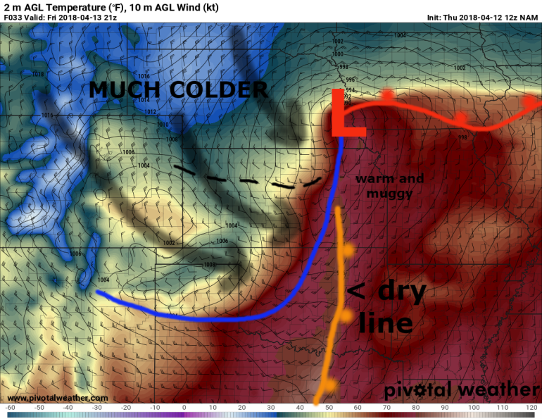
That moisture…combined with highs well into the 70s again will help create instability during the afternoon. Here is the surface set-up for Friday at 4PM…
Here is a “future” radar forecast off the hi-res NAM model…this will go every 3 hours starting at 7AM.
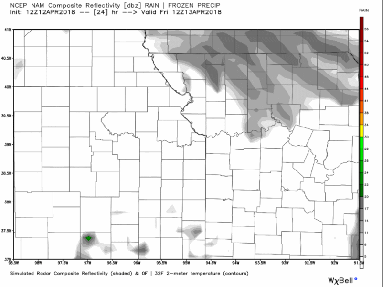
While some weird “appetizer” VERY fast moving showers are possible…the “main event” will be after 4PM I think. Storms should initially move into NE KS/NW MO and then head into IA.
Along the trailing cold front/dry line (a dry line separates gulf moisture and typically very dry air) other storms may form. Those would be the ones to watch for the KC Metro area. They will be somewhat more scattered in nature and will be flying towards the NNE at close to 50-60 MPH probably. When storms move that fast…it increases the chances that the turbulent motions within the cloud have a better chance of working down towards the ground in the form of 60 MPH+ winds.
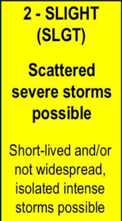
As far as the severe risk goes…the area is under a “slight>enhanced” risk.
What exactly do these phrases mean though? That’s what I want to talk about today. I sort of alluded to this yesterday and I realize many of the readers of the blog are more “into” things…but for the more casual readers…let’s briefly review.

The word “slight” drives me absolutely nutty. IF I said there was a “slight” chance of rain one day…odds are 1) it wouldn’t rain in your area and 2) you may not really pay attention to the chance of rain changing as the day evolves.
The word “slight” though, when it’s associated with how we communicate severe weather risk has a different meaning.
For a Day 2 outlook…like I showed above, the categories mean this.
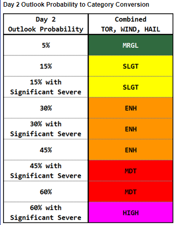
So since tomorrow the area, mainly on the MO side is under an “enhanced” risk of severe storms…you can see by the color depiction above that the chances are actually 30%+ for 25 miles within the “enhanced” risk area.
I know…confusing right?
Oh and when I show you tomorrow the new risk areas…all the above information in terms of probabilities will change to this.

Thankfully by going to this site…you can call up whichever outlook you want to see…and then for the Day 1 outlook…click on it…and then scroll across the winds/hail/tornado chances. In the weather world though…things again are a little weird. When we see 5% or 10% chances of a tornado (you would think that’s a very low chance…but in our world that’s a significant risk…and the higher the percentages go…for example to 30%+…watch out!.
The whole process is somewhat convoluted in terms of actual communication with those who aren’t really “in the know” which is about 99.5% of the population I think.
That’s what I’m here for.


