
We are stuck in a gray rut around these parts and there aren’t too many signs that we’ll see much sunshine for a few more days. The payoff in the end though will be a two day run of 60s…a great start to February…and all timed out for the Super Bowl on Sunday and hopefully some big time celebrating on Monday.
The record on Sunday is 69° and that is in play I think. Tough to get there but not out of the question. Remember earlier THIS month we were 66°…so it’s not as if it can’t happen. My analysis of what’s coming compared to the 9th when we hit 66° is that this air mass will be even warmer above us…so a run towards 70° is possible with the right combination of sunshine and wind.
- Forecast:
Today: Cloudy and blah with steady temperatures in the mid 30s
Tonight: Some light snow is possible overnight…after 12AM it appears. Minor accumulations are possible…under 1″…if that. Temperatures near 30°
Tomorrow: Cloudy and blah with highs in the mid 30s
Thursday: Not a lot of change…mid 30s
- Discussion:
Ugggh.
Nothing good about this look.

So much cloud cover.
The clouds around us really aren’t doing anything…just keeping temperatures up at night and cold during the day. So just blah overall.
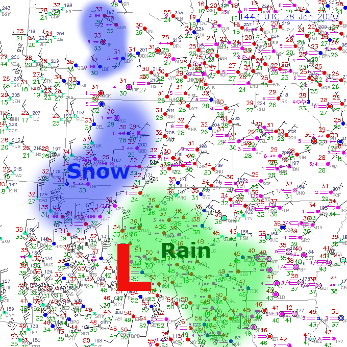
Farther to the SW there is a decent little snowstorm in progress today…but most of that snow will remain south of the area today and tonight.

The 8AM map shows the rain and the snow from that activity above…
The latest watches/warnings from out there look like this…via Pivotal Weather

There have already been some localized 13″(!) totals from this storm in a few areas near Sublette, KS.
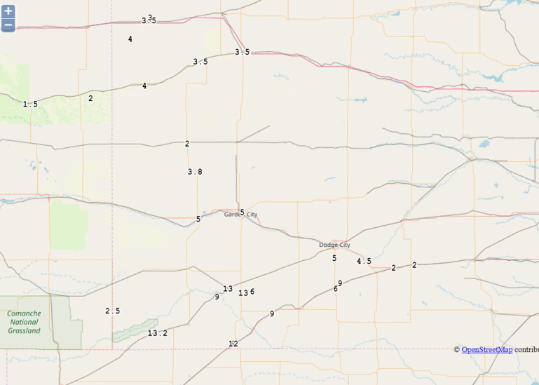
3-6″ around Dodge City with decent snow falling right now there.
In terms of the play-out from this storm…here is the short range HRRR.

For timing purposes…18Z is Noon…21Z is 3PM…0Z is 6PM…03Z is 9PM…06Z is 12AM and 09Z is 3AM.
For us here…this is actually a 2 piece complex…one piece moving north of the area and the more significant piece moving south of the area. We’re right now, at least, just not in a favored area for getting much snow. Some data overnight and this morning barely gives us any snow at all.
I don’t want to go there at his point but it doesn’t look like a lot. Areas farther north and south are more favorable for 1-2″ or so. The southern storm though will become the more dominant system in terms of snow production and that will be more of an I-44 situation compared to an I-70 situation.
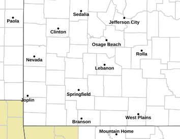
Winter Weather Advisories are in effect for areas south of KC towards the Lakes and southern MO as illustrated in blue below.
It appears that we’re just not in a good spot. Also the data this morning shows a lot of dry air above us that will take a lot to saturate and with both systems splitting around us…that could be a tough ask.
The data also shows a persistent moisture field that is just stuck on the area…from the surface up to about 3,000 feet or so. There won’t be much of a wind either in that moisture field…so in effect it’s just sort of there and will not break up.
In time this will break up…perhaps a bit on Friday…then more on Saturday.
From there we start the surge. Data continues to show temperatures near 60° a few thousand feet above us on Sunday and Monday. That is a recipe for a big warm-up here at the surface…assuming we get 1) sunshine and 2) enough wind. 60s to near 70° is on the table for Sunday and Monday.
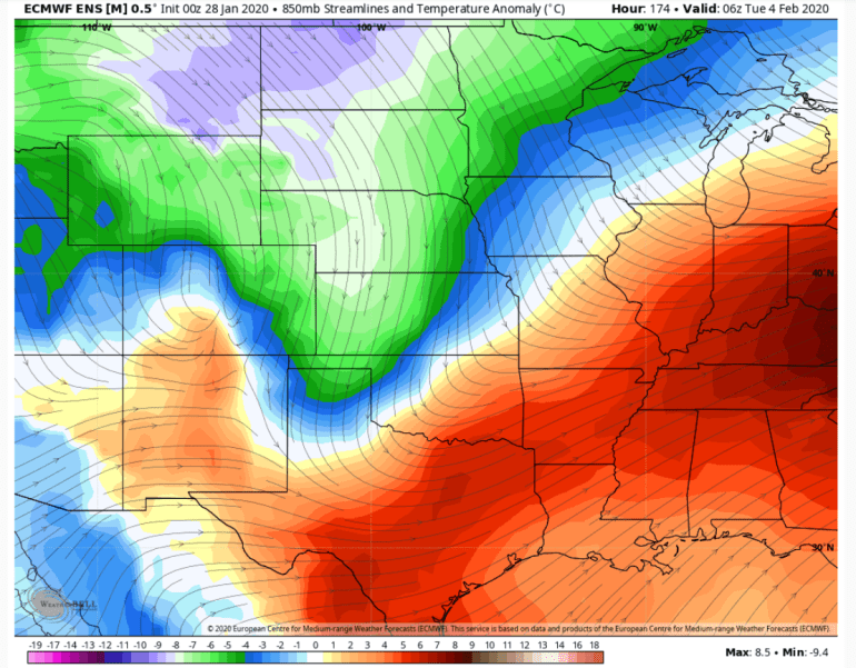
I mean when I see this…and I first sent out a heads up about this last Friday I think…wow! This map is valid at Noon on Sunday
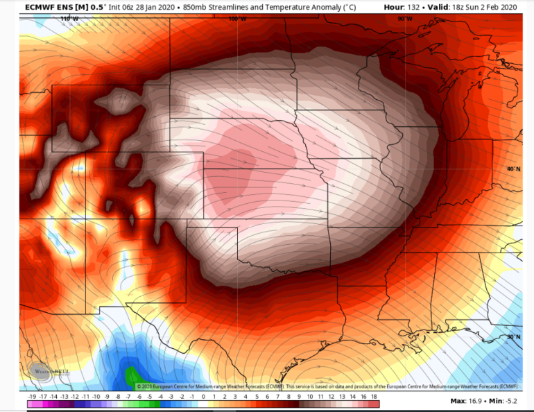
The map above shows the anomalies at about 5,000 feet or so…in °C no less…so just about double that. Out west that would be close to 35° above average temperatures at that level…which taking into account elevation changes out there…is closer to the surface!
For us the ensembles show 60-65° weather and they won’t take into account the extreme potential of what could happen. I think mid 60s are VERY doable.
The WILL change later Monday into next Tuesday morning it appears…as some modified near arctic air comes zipping through for Tuesday and Wednesday…odds are 20s are coming back (for highs) for a couple of days at least.
This cold air mass will come and go over the course of about 2-3 days though…
There should be at least some snow with this…not sure about a “snowstorm” out of this transition but at least some snow is likely in the region.
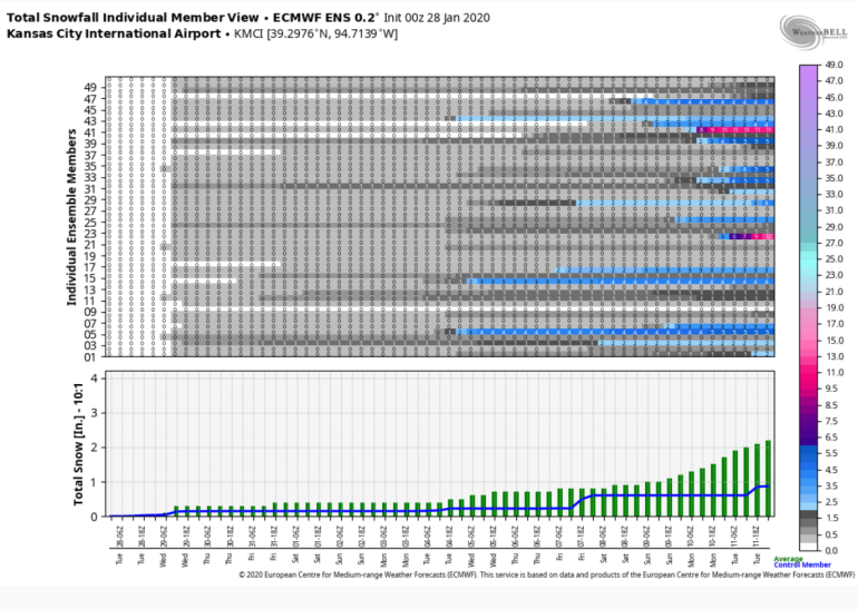
The ensemble snow data points over the next 15 days aren’t exactly a thrill to look at…if you want snow that is.
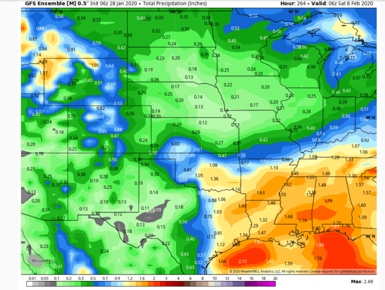
and when I see this…from a moisture standpoint through the end of NEXT week…color me unimpressed. Total precipitation through the 7th. 13/100″ isn’t exactly a thrill and about half of that is over the next 24 hours.
My feature photo comes from Tom Steger
Joe


