
Good morning…a dreary, gray and cool day is ahead for KC…although I’m not expecting much rain in the area today…and for most of the evening…just a passing area of drizzle or mist every so often.
What will make today unique is that the high should be somewhere in the mid>upper 50s. This will break a weird record…a record cold high temperature. The record (for now) is 66° back in 1907…this should be shattered as the day moves along. So it’s a weird record to set in a way…but it will be broken.
We may do this again tomorrow. The record cold high is 60° set back in 1898. I’m forecasting a high of 58° right now. We should be warmer on Friday.
Rain will be more prevalent in the region after today as well…with lingering chances into Saturday.
+++++++++++++++++++++++++++++++++++++++++++++++++++++++
Forecast:
Today: Cloudy and misty at times. Chilly and raw with highs in the 55-58° range. Not as windy as yesterday.
Tonight: Cloudy with rain developing towards daybreak. Steady temperatures in the lower 50s
Tomorrow: Off and on rain. Not a pretty day. Can’t say the rain will be done by the game either. Prepare for rain if you’re tailgating or going to the game. Highs in the upper 50s
Friday: More rain chance although it may get a bit milder with highs in the mid>upper 60s
++++++++++++++++++++++++++++++++++++++++++++++++++++++++
Discussion:
Not a pretty day…as the satellite pictures sort of tell the story for the day overall.

Quite the situation really as low level cold air continues to drain into the area…while above us the air is warmer. This low-level air is about 3-4,000 feet thick or so…then above that the air is roughly 60°. Here is the morning surface map with the temperatures in red.

It is still on the 30s for a few areas out west too…especially towards the Rockies where snow is continuing.
I mentioned today would be a record-breaker for the KC area in terms of setting a record cold high temperature for today’s date, September 9th. We won’t be alone today. Many of the cities that you see below are going to threaten this same type of record. The numbers represent the NWS forecast for the particular cities.
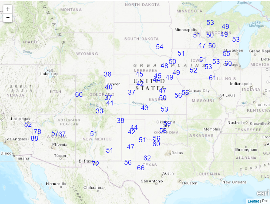
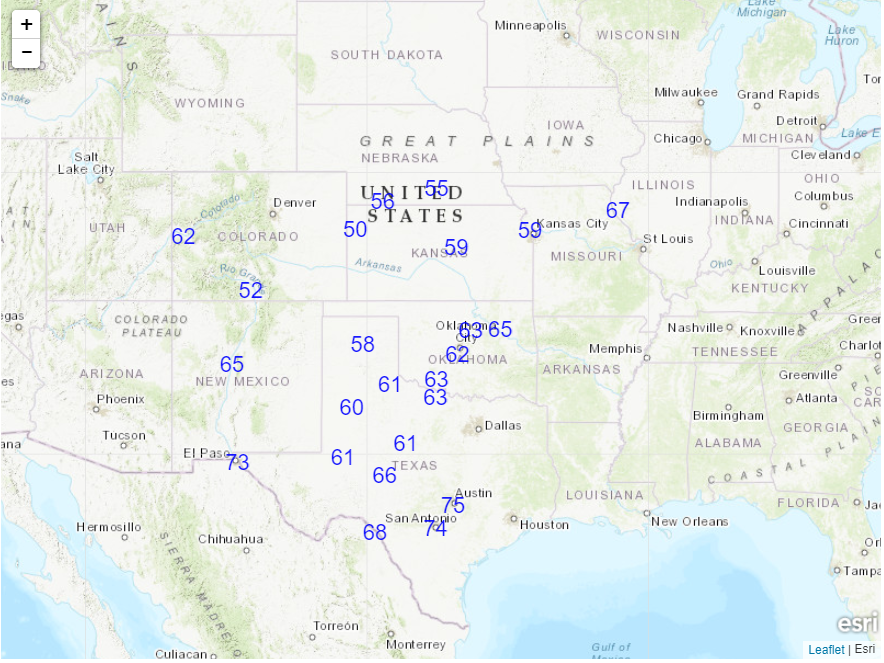
Tomorrow may be the same as well…
In the last 24 hours…12-24″ in the red colors have fallen in the higher elevations of the Rockies. That’s impressive for the 1st 10 days of September.
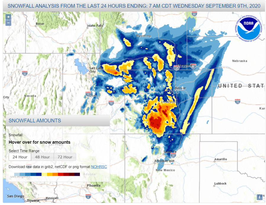
In some cases yesterday snow was falling on top of the fires that were ongoing out there.
Here’s something else…in one of the previous blogs I mentioned that the quickest turnaround from 100° to measurable snow was 5 days…well Denver did it in 3 days…but the record is in Rapid City, SD.
Well they broke their own record.
Meanwhile the western fires are still burning. CA and OR have really been hit hard…and the smoke is just incredible.
CA has been especially hard hit…even compared to last year.
The same storm responsible for the snow in the Rockies and the occasional bouts of rain locally is helping to spread strong downsloping winds into the western US…these winds can accelerate as they come down the slopes and with the dry conditions and the ongoing fires spreading rapidly…it’s a bad combination.
Oregon is also seeing this form of “Santa Ana” winds…and the fires there are spreading. Medford, OR had a bad night last night as parts of town were evacuated. It’s being considered a “once in a generation” fire that is occurring in that area. Today won’t be any better.
Meanwhile remember the Oroville Dam in CA…a few years ago during the winter of 2017…it was in danger of collapsing? Well there is a new fire threatening that area now…
Back to KC…the upper level storm will be spinning around the west before coming out into the western Plains on Friday. As it does so little disturbances will be coming up the I-35 corridor and create waves of rain. Precise timing of those disturbances and the rain arrival and ending are almost impossible really. We do know that we’ll be vulnerable to this tomorrow and Friday. Here is a look at the 18,000 foot map showing the upper level storm out west…and the little waves coming up from the SSW…
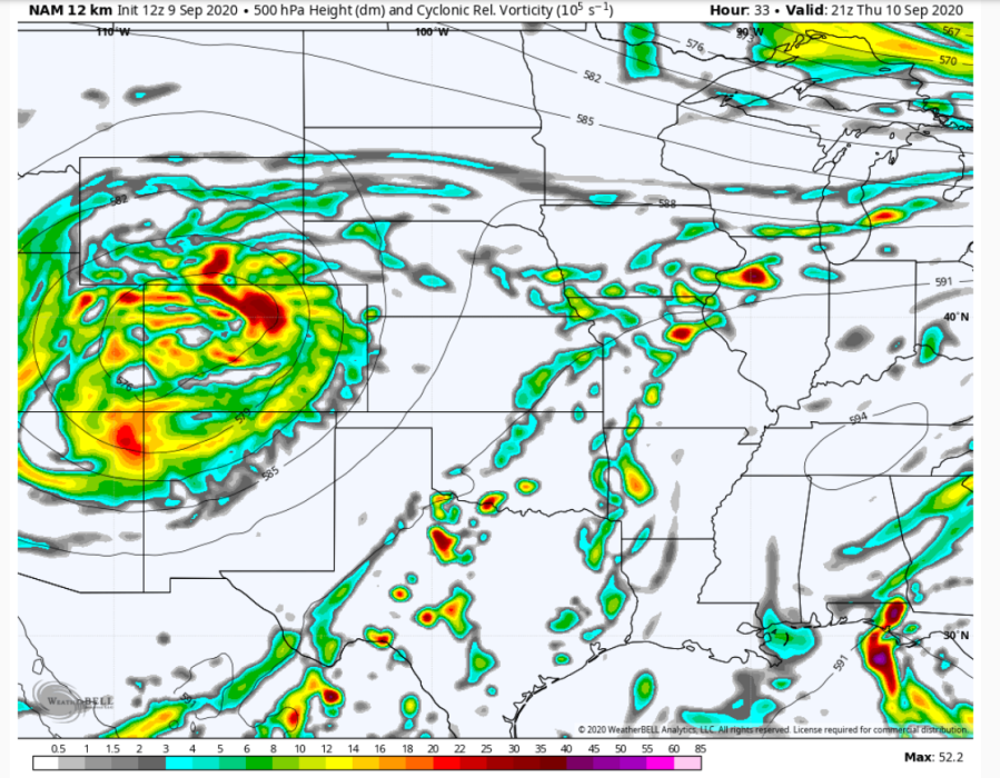
That upper level storm will move into the upper Plains over the weekend…until the flow aloft changes..we’ll be vulnerable to rain chances.
There may be some pretty good rain producers as well out of this…and I wouldn’t be shocked if a few counties somewhere in the viewing area see over 2″ of rain. Where exactly remains to be seen but there is a lot of warm and moist air above us to be tapped into as the rains move up from the SSW.
I can’t rule out some storms/showers even later on Saturday as we warm back up to around 80° or so. The air aloft will be cool and that should create some decent updrafts later in the day.
We need the moisture in many cases so I guess that’s a good thing.
Barry Evans has the feature photo today…

Joe


