While Isaac has been devastating for much of the country that it has directly affected, for us, while the timing is not great for the holiday weekend, it is bringing welcome rainfall and the rain has been slow and steady now for a few hours, longer to the S/SE of the metro and it’s nicely soaking into the the hardened soil. Here are the updated probabilities.
CHANCE OF ISAAC AFFECTING OUR WEATHER WITH A TRACE OR MORE OF RAIN: 100%
CHANCE OF ISAAC AFFECTING OUR AREA WITH OVER .25″ OF RAIN: 100%
CHANCE OF ISAAC AFFECTING KC WITH WIDESPREAD 1″+ OF RAIN: 100%
ALL CHANCES ARE HIGHER OUT TOWARDS THE LAKE OF THE OZARKS THROUGH CENTRAL MO
So Isaac will be a big player n the forecast for the next 48 hours or so, the rain is still expected to be heavier off towards the E/SE. Amounts of 1-3″+ are still likely as the remnants slow down again and give parts of central and eastern MO a great soaking. For us the heaviest rain totals should be today and overnight tonight, the activity will be a bit more scattered tomorrow PM and should wind down tomorrow night. Clouds will be the issue on Sunday but should scatter out by Sunday afternoon. So in reality the worse of the weekend weather will be winding down tomorrow afternoon. So 2/3rds of the holiday weekend will be OK. Toasty weather expected again (with more humidity) MON-TUE of next week.
On the eastern side of this towards St Louis, where there is a bit more heat today and mid-upper 70s dewpoints and SE winds, severe weather is a concern. There is a Tornado Watch in effect for Eastern MO as I type, and a couple of warnings have been issued for the St Louis area as well. so far as of this typing the worst reports have been some wall clouds with the storms.

At this point I’m expecting rainfall totals for the metro to be in the 3/4″ to 1 1/2″ (1-3″) range. Areas on the SE side of KC may get the higher totals while the NW side will be on the lower side of things.
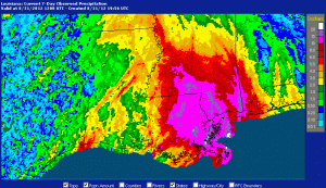
Speaking of rainfall, the amounts down to the south have been very impressive to say the least. Check out this map from LA/MS showing the 10-20+” that were indicated on radar.
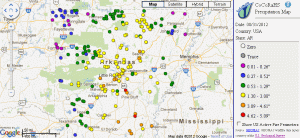
In AR the amounts were impressive as well…remember AR is going through a nasty drought as well. Click on that image to make it larger.
I mentioned just how bad the drought is down there…take a look.

The latest from HPC shows the heaviest axis of expected rainfall. My feeling is that some of those numbers are a bit on the high side…but the system will be slowing down over the weekend.

Notice through the metro, a 3/4″ to 1 1/2″ swath is forecasted…it should not be overly heavy at any one time.
Reports from the SE of KC indicate already nearly 1 1/4″ of rain has fallen towards Whiteman AFB and Sedalia.

Let’s enjoy the rainfall…it’s but a drop in the bucket but it’s certainly welcome!
Joe


