Lets take care of the latter first as Isaac is still a tropical storm at this writing packing winds of close to 60 MPH and starting to show some additional signs of organization as it starts ingesting some of the warm Gulf Of Mexico waters that are in it’s path. Water temperatures down there are in the 85-90° range which is like gasoline to a fire when a tropical cyclone is trying to energize itself. Here is a look at the radar from the NWS in Key West, FL where winds have been gusting to almost 65 MPH. You can see the center of the storm not far away from the Islands.

If you want to take a look at the loop of the radar…go here. You can clearly see it spinning towards the WNW or NW. Hurricane Warnings are in effect for the Keys area as well as other parts of S FL. Here is the forecast from the NWS in Key west for the day…not looking to pretty.

So what is Isaac going to do and where will the storm go? The latter is the trickiest, the former should be easy. It will intensify, how much is a question but there is potential for this to become a 120 MPH type hurricane as it approaches landfall sometime late Tuesday night or Wednesday somewhere along the northern Gulf coast area. The modelling is ALL over the place concerning that potential and this will have ramifications on you belief it or not. Why, well there are thousands of oil wells out there that are in the process of shutting down. BP and Shell (I’m guessing others as well) announced this AM they are shutting down most of their rigs for awhile and preparing to evacuate their personal. Just how many rigs are out there…take a look.

Here’s the rub…29% of the US oil comes from them and they hold 40% of our refining capacity along the Northern Gulf Coast. These days any supply disruption causes price spikes and I fear we may be looking at something like that for a while. So this is a major concern. The track of storm is ALWAYS elusive and the models have been waffling and showing a more westward trend over the past couple of days compared to the “official” NHC forecast. The issues of the latest GFS are abundant because it would open up the New Orleans area to some potentially tragic situations, including flooding associated with Lake Ponchartrain. Once you bring that up, you start to talk about the events associated with Katrina from about 8 years ago. That is something that brings nightmares to the folks down there, because while the storm may not be as strong as Katrina in terms of winds the critical path of the storm could create all sorts of problems. Here is the current NHC forecast of Isaac. Interestingly IF it its on Wednesday it would be on the 7th anniversary of Katrina! The latest EURO has this as a landfalling hurricane near Mobile Bay. So a large discrepancy continues with the interpretation of the models.

Landfall is now near Biloxi and Gulfport, MS. Again note the west trend compared to a couple of days ago. Don’t be surprised IF this gets nudged farther west as the next 2 days come along. Any farther west and New Orleans is in play in a huge way. What you also need to remember is NOT to focus on the center points of that forecast track…it’s better from a preparation standpoint to focus on the “cone” of uncertainty because it shows the potential landfall area better. we are confident that the storm will be well offshore of W FL through tomorrow, bringing some squalls, gusty winds and occasional rains to W FL perhaps, but in reality it should not be too bad for the Tampa area. They need to also watch for storm surge with this at times of high tides for some low land flooding. Speaking of storm surge…why are we so concerned for New Orleans..take a look at a model called the SLOSH model that takes the forecasted track of the storm and estimates the storm surge…

The shades of colors and the key on the right side represent the storm surge. Depending on the timing of the storms surge (high or low tide) this again may be a tragic scenario unfolding along the Northern Gulf Coast.
Here is a look at the satellite images…it’s been a fascinating storm and it too has been very difficult to forecast.

Now onto the matters at hand our weather. This storm was problematic for us for sure and created a localized busted forecast for the KC Metro area. If you’ve been following the weather blog for the last couple of days you know I’ve had concerns about the model forecasts about the “potential” for this storm. This is from Wednesday:
“At this point I’m remembering all to well the systems a couple of weeks ago that gave us great looking swirls of disturbances on the satellite images but really generated “minor” rainfall amounts, despite the fact that it did rain over a few days. I’m still not comfortable forecasting amounts for the weekend. I am comfortable in saying there should be a lot more cloud cover dropping highs into the 80s, and depending on the timing of the rain, maybe only in the 70s for awhile. Our microcast model late last night painted a 2-3+” rain for the I-35 corridor, I think the chance of that happening is slim at this point.
Looking at the 1st bits of new data this AM, it seems to confirm what I forecasted yesterday that the better chances of decent rainfall would be to the NW of KC, up towards NW MO and NE KS. Again this could change and there could be a southwards shift, but until these things actually develop and move closer, I won’t be confident that we’ll get anything more than minor amounts (under 1/2″), which is an average Summer would be great, but in a “exceptional” drought is really a pittance”
Now from Thursday…
“if you remember the last time this happened we had all those neat swirls of clouds and sadly, dying rains, move across KS and really not do to much for us, and this very well may happen again on FRI and SAT. So while I’m sticking the chance of rain in the forecast at this point I’m not as optimistic on the totals as the NAM would suggest through later Saturday especially for areas NW of the metro.”
Then on Friday…
“The models have slowly been ratcheting down their rainfall forecasts. Some will do very well I think over the next few days with the potential of 1-2 1/2″ of rainfall somewhere in our region. To me the odds favor N MO and NE KS for this potential. There may be some rather heavy downpours associated with these set-ups as the atmosphere will be loaded with moisture which is a good thing! There is some upside potential as well so between the rain and the runoff (since the soil is so baked and hard there will be more runoff than usual) hopefully while the ground should get a good drink of water we should also see some recharging of the ponds/lakes/streams that are so important for future irrigation.
Closer in to the metro the rainfall while likely and decent (with upside to the totals) is a little more problematic. Mainly for the timing and also for the totals. The modelling has been trending down with the totals over the last few runs. The 12Z data yesterday had 1.4-1.8″ of rainfall…the 18Z data yesterday had .65-1.4″ of rain…the 00Z data had ,83-1.22″ of rain and the 6Z data had ,93-.7″ of rainfall. All this data was for KCI. The rainfall totals is the hardest thing for the models to predict. There are just so many variables/interactions that the modelling can’t really see. They can show potential though and that has to be respected.”
Finally here was part of my blog from yesterday…
“There is a disturbance near Emporia slowly moving NEwards. As it does so the wall of rain out west should inch closer to the metro and eventually move in. This will be part one of the storm for the KC area. Part two should come tonight as the low level jet runs over a boundary left over by part 1 of the storm. This should create new rain and perhaps even some thunderstorms that should move through the region overnight into tomorrow AM. This should be the bulk of the rainfall for the KC area. There is potential for upwards of 1.5″ of rain, but at this point I’ll stick with my near 1″ of rainfall for the metro area and hope I’m being too conservative. Areas SE of the metro may have a tougher time with all this because I’m not expecting much today and tonight’s activity may be to the NW of them for a while. So amounts there may be near or below 1″. Again hopefully I’m being to conservative.”
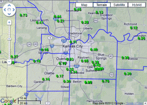
OK…that is the groundwork of the forecast for the last few days from the NWS radar in Pleasant Hill, MO, we’re talking close to 5-8″ across NW MO (Tarkio had 7″) shaped up.

Most did OK to great out of this, one look at my emails and FB comments and you can see all the 1-2″ reports…the problem is that most of our viewers live in the KC Metro area from KC south towards Grandview and from Lawrence east to Blue Springs, that’s the bulk of the population in the KC area. It was in this region that the rainfall amounts were much more paltry. Click on that image to make it larger.
For my forecast itself I was thinking 1/2″-1″ out of this for the KC metro area…I mentioned that we could get more but again I was concerned about the weird way the storm was evolving. In reality the amounts were about 1/2 less than I forecasted for the Metro area.
In a normal year that would’ve not been an issue but in a drought everyone was hopeful. MT even got into the hopefulness on Friday night thinking some could see upwards of 1-2″. In reality that forecast was fine…except for where the vast majority of the people live. Raymore and Belton both had about 1″…so close yet so far. Heck KCI ended up with about 1/2″ of rain out of this…but so many others struggled. VERY frustrating.
It’s important to note that my forecast Saturday was a poor one for that day itself. I really though we’d be into the rain for a good part of the afternoon and in reality we were into the rain for about 1-2 hours in a spotty fashion. That was NOT a good forecast. Today has evolved as expected..we may even pop a few showers later this afternoon as we try to warm up a bit.
There have also been comments on FB and email about how meteorologists are a slave to the forecast models. I understand those concerns, but as you can see from my blogs this week, I pointed out where the models were potentially overstating things and why I had my concerns about their accuracy in this situation. The thing about it is…the models nor the humans can predict a doughnut hole of light rainfall amounts in the KC area surrounded by correctly by a pretty accurate forecast. They are good for generalities (for the most part) but for absolute specifics they aren’t perfect…and neither are the humans.
Have a great day and Isaac will be the topic of many a blog in another hot week for KC!
Joe


