Our weather will be rather tame for the next 4 days or so as summer hasn’t given up on us yet. I’m expecting a pretty toasty week as I’ve talked about over the weekend with highs creeping into the 92-97° range TUE-THU. After that we may get a break from the heat heading into the Labor day weekend, and yes it’s becoming increasing possible that we’ll see some of the effects from Isaac as it moves into the middle part of the country and moves across, at least part of MO. Whether or not we can get significant rain out of this remains to be seen, but last Wednesday I said there was a 1% chance we could feel the effects from this storm in the form of rainfall…last night it was 3% and this AM I’m increasing that to 15%.
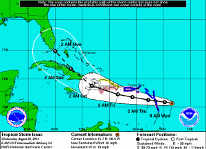
What’s been happening over the last several days is that the future track of Isaac has been coming further westward with time. Remember it was about 5 days ago that the southern part of FL was supposed to be hit by Isaac when the initial forecasts of Isaac were being issued. Again this is an OLD track forecast.
So now look at what we’ve got for where Isaac may end up going.

In actuality, I think the Hurricane Center has done a good job with the storms forecast track over the last 5 days or so…I just reviewed all the forecasts issued by looking at the archive of their forecast tracks and they are doing rather well with this. The intensity forecasts have been overzealous but intensity changes in these systems are admittedly the tougher aspect of the forecast sometimes, and especially with Isaac as land interactions have created headaches.
Notice where the track of the storm is forecasted to be Friday night into Saturday. That would certainly be close enough to give us abundant clouds and IF that track were to verify at least rain would fall on the MO side. The problem closer to KC for the rainfall is that we’re on the wrong end of the storm. The west side is not the side you want to be on, especially when you’re west of what’s left of the center by some 150 miles or so. I would REALLY like to see this come even another 75-150 miles farther west for us to really get excited about the potential of decent rainfall.
The reconnaissance aircraft investigating Isaac this AM (still at this writing a Tropical Storm with 65 MPH winds, are reporting somewhat lower pressures in the storms center and an “eye” trying to develop. This indicates that Isaac is trying to intensify and my become a hurricane sometime today. Here are the satellite pictures of the storm.

What we’re looking for is for the center of the storm to work it’s way underneath the bigger storms that are trying to form. As this occurs the storm should intensify nicely. That’s been an issue for this storm for the last few days. It’s having issues trying to “sync up” if you will. Here is a color enhanced view of the storm.

The morning forecast models are out and indicating that New Orleans seems to be the targeted area for landfall, or at least very close to landfall since there are outer Islands SE of there that would be affected first.

If you notice the future tracks up in the MO area, many of the models are still taking this more towards the Bootheel (good for them-not as good for us) as opposed to closer to us. Some of the models are still optimistic about the remnants closer to KC.
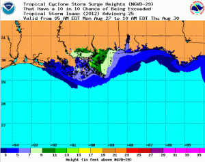
The main concern with this storm will be the storm surge into the LA/MS area. Here is the latest projections that will certainly change some, but I think you get a good idea where the highest surge, some 10-15 FEET would be. Click on this image to make it larger.
They’ve rebuilt most of the flood walls down there in New Orleans…this will be the 1st real test for them.
As usual whenever something important is going on down there, the website nola.com does an amazing job keeping folks updated with more local specific information.
Joe


