
This blog is a story of two seasons…and both come our way between today and Sunday/Monday…with an expected cold and swift turn in the weather later Monday into Tuesday as more cold air returns.
Its a roller-coaster ride for sure but the timing of things means that after about 1″ of snow this morning…we’ll challenge record highs on Sunday in KC. The record is 69° and it’s in play
Meanwhile this morning it’s the usual somewhat messy morning rush hour as about 1/2″-1″ of snow moved through areas south of I-70 with lighter totals north. I got home last night around 11:30 with snow falling…that snow took about 4 hours to get towards KCI…about 2 hours for the downtown airport to report snow compared to areas a bit farther south
- Forecast:
Today: Snow exits by 9AM on the MO side of the Metro…then cloudy and cold. Highs around 32°
Tonight: Cloudy and cold…lows in the upper 20s
Tomorrow: Cloudy and cold with highs in the 33° range
Friday: Mostly cloudy and cold with highs in the mid 30s
- Discussion:
Enough to be a nuisance but the well predicted snow did about what we thought it would do. Usual accidents in most of the usual places when there is snow on the road…
Onwards…
The case of the blah weather continues. This wave coming through isn’t strong enough to create enough sinking air to rid the persistent cloud cover in place.

These clouds will hang with us into Friday it appears.
So let’s take a minute to check in the with the snow totals so far this season.
The snow that we saw overnight…will keep the air refrigerated today and tomorrow. Cold air with some moisture trapped and a light wind regime at the surface and above isn’t a great combination for sunshine around these parts.
This moisture combined with a couple of disturbances coming in the flow could allow for a few patches of light snow into Friday before we start the transition to warmer air.
The changes begin in earnest on Saturday as much warm air comes through the Plains in what is a classic downslope warming event heading this way. It’s the reason I’ve been pushing the big warm-up now for Sunday for about 5 days.
The air will be coming from the elevated terrain in the western Plains to the lower terrain in the eastern parts of KS and MO. This aids in taking a milder air mass and making it even warmer. With the air being dry as well…and with sunshine and enough wind we will soar on Sunday.
We have a history of seeing milder temperatures this winter…we’ve been in the 60s in December and January. The chart below shows the high temperatures so far since 12/1.
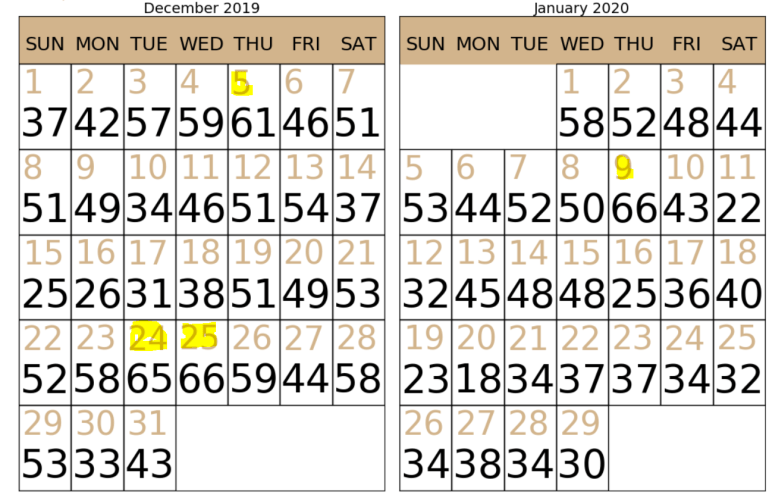
That’s 5 days with temperatures in the 60s since December 1st. 6 other days with highs 55°+. So 10 days out of 60 with temperatures at or above 55°
So it can happen..and this air mass coming our way is forecast on the data to be the warmest (at least a few thousand feet above the surface)…that we’ve seen all winter long…that’s why I think there may be a run towards a record high of 69° on Sunday.
We’ll see how the winds help or hurt this attempt. They’re not exactly blowing like crazy but then again…we’re now coming into early February…5 weeks after the start of winter…so the sun angle is equivalent to mid November and that might be helpful to getting us a couple of extra degrees.
So we’re primed and that’s why I’ve been so aggressive with this potential.
The next issue is does it last through Monday?
I think it will at this point which means Monday will be mild. A cold front though will be coming through the region at some point later in the day into Monday night. This will usher in the usual February cold air mass but it will be a sharp contrast to what we enjoy on Super Bowl Sunday and Monday from a temperature standpoint.
The cold front will slide through at some point later Monday and usher in the colder weather that is typical. Temperatures on Tuesday will be closer to 30° and I wouldn’t be shocked if were mostly in the 20s. We’ll probably have a midnight high early Tuesday of whatever then see falling temperatures.
Next issue…snow.
I’d be surprised IF we didn’t get something from this transition. A persistent SW to WSW flow aloft above the colder air below that is a set-up for something to happen. Not sure IF there will be a big storm…but another impactful snow is possible sometime in that TUE>WED time frame I think…several inches may be on the table with this change.
That will be worked on over the next 5 days or so,
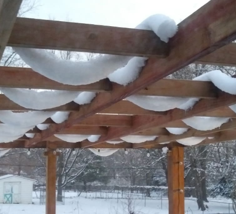
Our feature photo comes from Paulette Moore from the wet snow we had last week!
Joe


